Tampilkan postingan dengan label ODOT. Tampilkan semua postingan

Rabu, 25 April 2012

The first shaft for the viaduct path is under construction.

From ODOT-  By early 2014, improvements to the park paths near the new Willamette River Bridges will be complete.  The most significant change, a new viaduct path on the south bank of the Willamette River, will replace the current path that connects to the south side of Franklin Boulevard, east of the bridges.


Bridge beams reused from the Interstate 5 detour bridge will provide a structure for the realigned path.  The beams will be supported by 14 individual bridge columns spaced along the riverbank.  Rebar and concrete will fill drilled shafts to a depth of at least 10 feet into the bedrock.


We've recently taken the first step in constructing the viaduct, by drilling a shaft beneath the new northbound bridge.  This had to occur now, because the drilling equipment is too tall to fit under the new northbound bridge once it is built.  This may be the only work we do on the viaduct path until this fall.


As you can see, the drill is taller than the new southbound bridge and would not have fit under the soon-to-be-built northbound freeway bridge.


Here, workers line up equipment to place the steel retainer ring, which will prevent dirt and rock from falling back into the drilled shaft.

Selasa, 10 April 2012

New paths will feature safety improvements.

From ODOT-

ODOT is working closely with the cities of Eugene and Springfield to enhance and improve safety on pedestrian paths along the banks of the Willamette River near the new Interstate 5 bridges. Some changes are already in place but most will be finished in late 2013 or early 2014.


Crews have repaved and striped the Canoe Canal Path and the paved paths on the north and south banks of the river under the bridges. They are also minimizing dangerous corners and intersections and eliminating a large drop in the path on the north end of the Knickerbocker Bridge. Path users will see new landscaping, including native species of trees, shrubs, flowers and prairie grass. A new path on the south bank of the river will link existing routes and provide great views of the river. It will start east of the Knickerbocker Bridge, follow the riverbank under the I-5 bridges and connect to Franklin Boulevard. The city of Springfield plans to extend this new path to the intersection of Glenwood Boulevard and Franklin Boulevard.


We enjoy working with local partners to make these path improvements for the benefit of users for years to come.

Selasa, 06 Maret 2012

Restoring the Whilamut Natural Area


From ODOT- Long before it was named the Whilamut Natural Area, the Kalapuya tribe inhabited this 70-acre site on the north bank of the Willamette River west of Interstate 5. The Kalapuya gathered food, traveled on the river and hunted local game. Later the site served as farmland, supplied sand and gravel for the original I-5 bridge and was used as a Lane County landfill from 1964 to 1974.


Transformation of the site continues today. The City of Eugene and volunteers serving on the Citizen Planning Committee oversee efforts to restore the area to its natural state. Removal of non-native plant species such as blackberries, Scotch broom and tall fescue allows native species to survive and thrive. Planting of native grasses and wildflowers creates new upland prairies for wildlife habitat. Western meadowlark, vesper sparrow, woodpeckers, lizards, gopher snakes, frogs and turtles are expected to return and thrive.


A new forest canopy of black cottonwood and Oregon ash will protect plants needing shade while providing wildlife habitat and a cool zone along the river for juvenile Chinook salmon.


As the restoration proceeds, bicyclists, walkers and runners use the variety of hard and soft paths to travel east, west, north and south. Some stop to enjoy the river or just sit and experience the natural surroundings.


Future generations will appreciate the opportunity to see cycles of nature and flourishing native plants and wildlife.


Senin, 06 Februari 2012

New pedestrian path on south bank of the Willamette River


This picture shows the route for the new path on the south side of Franklin Boulevard.


From ODOT- Construction crews are preparing the south bank of the Willamette River under the vicinity of Interstate 5 for a new pedestrian path set to open in spring 2014. ODOT is building the path in cooperation with the cities of Eugene and Springfield.


This direct, safer route for pedestrians and bike riders will start east of the Knickerbocker Bridge and run along the riverbank until it joins a new path constructed by the city of Springfield along Franklin Boulevard.


This will be no ordinary path. Beams saved from the recently demolished temporary I-5 detour bridge over the Willamette River will be supported by concrete columns to create a viaduct that will offer great views of the river and new bridges.


The city of Springfield will continue the new path to the intersection of Franklin Boulevard and Glenwood Boulevard. Traffic signals will make the intersection safer for path users crossing Franklin Boulevard. Eastbound bike riders will share a wide sidewalk with pedestrians, and westbound cyclists will use a path on the south side of Franklin Boulevard.


We are very excited about these improvements!


Jumat, 06 Januari 2012

ODOT approves design enhancements for north bank natural area

From ODOT-

ODOT has approved two design enhancements proposed by Litus LLC for the Whilamut Naural Area near the new Interstate 5 Willamette River bridges.


Blue engraved stones will be installed on the slope south of the Canoe Canal Path under Interstate 5. Fifteen stones will depict the life cycle of the abundant camas, from the bulb's edible underground roots, to its open flowers, to its seeds falling to the ground.


The designs reflect the "Whilamut Passage" theme selected by the community in 2009. When completed in 2014, the installation will enhance local understanding of the Kalapuya culture and the area inhabited by Native Americans.


Teams from the Community Involvement and Long-term Ownership Strategy (CILOS) will participate in the restoration of 3.5 acres of land in the Whilamut Natural Area. They will restore the Willamette Valley upland and prairie habitat by removing non-native vegetation and planting native species. They will add design enhancements consisting of singing perches for birds created by supported tree snags. Some 14 local schools working in groups of 20 - 40 students per school will complete the project over three years. Ongoing education and awareness is an important aspect of this project.


Here's a rendering of the singing perches to be placed in the Whilamut Natural Area.


Over the past few months, a Design Enhancement Steering Committee has worked with the local designers to develop the final recommendation. The Citizen Advisory Group and the Project Development Team reviewed the designs at the end of November and recommended them to ODOT. We have approved the recommendation and will move forward with contracting with Litus for final designs, with installation to be completed by spring 2014.


ODOT appreciates Litus' work and all the volunteers who helped develop these enhancements. They will certainly benefit the area for generations.

Rabu, 30 November 2011

Waterways Surrounding the Bridges

From ODOT-

Do you know that besides the Willamette River, there are 13 other bodies of water surrounding our project?


Both natural and manmade waterways flow here. The Whilamut Natural Area is home to the Canoe Canal, also known as Patterson Slough, and two protected wetlands. The Canoe Canal water originates from a diversion structure built in 1974 east of the bridge and reconnects to the river near the Ferry Street Bridge. The wetlands retain rainwater throughout much of the year, providing natural filtration and supporting a diverse plant environment.


On the south bank of the river, an interconnected network of waterways includes eight wetlands and two creeks. Three of the largest are Laurel Valley Creek, Augusta Creek and the Glenwood Slough. Water from the Laurel Hill Valley neighborhood winds through this network and flows into the river west of the bridges. Located along Interstate 5, the Franklin Boulevard off-ramp and the railroad tracks, this network captures and naturally treats rain runoff.


Before construction began, we developed plans to avoid or minimize impacts to all of these bodies of water. As part of the Willamette River Bridge project, we will improve this system through stream restoration and new bioswales that capture and treat more of the runoff before it enters the river.

Kamis, 10 November 2011

Twin bridges, but not identical

From ODOT-

Soon, you will see the piers and foundations poured for the new northbound Interstate 5 Willamette River Bridge.


When finished, the northbound span will appear identical to the southbound bridge, but up close, you'll see a few significant differences.


What's the same:

The main arch spans crossing the river will be identical and both bridges touch down only once in the river, in stark contrast to the old bridge's numerous piers.


What's different:

The new bridges will be noticeably different on the south end where they connect to the roadway.


The southbound bridge has nine spans and a total length of 1,759 feet. The northbound bridge will have 10 spans and a total length of 1,985 feet. the additional northbound span will pass over the I-5 northbound off-ramp to Franklin Boulevard.


For the majority of their length, the two bridges will have a gap of 16 feet between them. But the gap will narrow as the two bridges meet the roadway at the south end.


Because of the small difference in the twin bridges, we save time and money by using the same design on both and incorporating lessons learned from building the first into the second bridge.

Jumat, 28 Oktober 2011

Hundreds of Volunteer Hours Make this Bridge Possible

From ODOT- I cannot stress enough how grateful everyone at ODOT is for the citizens who have donated so much time, effort and passion into making this bridge something we are all proud of.


A 12-member Community Advisory Group (CAG) has been instrumental in developing project goals, objectives and design considerations to ensure that community values are a part of the project. They have been meeting since 2007, and have included representatives from local neighborhoods, recreation groups, local artists, architects, the University of Oregon and the Citizen Planning Committee (CPC) for the Whilamut Natural Area of Alton Baker Park. The work on the enhancements has been guided by a Design Enhancement Panel (DEP), a diverse group of design professionals and community representatives, and a Design Enhancement Steering Committee (DESC) made up of four members from the CAG that continues to meet. The four members of the DESC are Charlotte Behm, Bob Kline, Vicky Mello, and Scott Wylie.


ODOT is fortunate to be able to include artistic enhancements on the project that will reflect community values and add cultural significance to the design. Esther Stutzman, a Kalapuya tribal representative, and David Lewis, representative of The Confederated Tribes of Grand Ronde, have played a large role in inspiring the design enhancements. They each set aside time to help develop the bridge's aesthetic values and to foster the designers through their work.


I'd also like to thank our citizen volunteers who have worked to have the bridge renamed the Whilamut Passage Bridge. While the name is not yet official, we are well on our way thanks to their efforts shepherding it through the process. Thank you, all. Your work on this project has ensured that it will resonate with this community for years to come.

Sabtu, 30 Juli 2011

What's in a name?

From ODOT- Local citizens have been working to get support for naming the new Interstate 5, Willamette River Bridge.


The name Whilamut Passage (pronounced "WHEEL-a-moot") is the theme of the project and guides the design enhancements surrounding the bridge. The theme recognizes the unique setting of the bridge in the Whilamut Natural Area, a place of historic and environmental significance. The setting is also a transportation hub of bicycle, pedestrian, rail, waterway, and highway traffic. To the Kalapuya, Whilamut means, "Where the river ripples and runs fast."


Local citizens have already accomplished many of the steps required for naming the bridge. They've received support from Lane County, the cities of Springfield and Eugene, and the Metropolitan Policy Committee. The Oregon Geographic Names Board approved of the name on June 25.


Because the name honors the Kalapuya, the Confederated Tribes of Grand Ronde must also support it. Once this step is complete, the proposal will go to ODOT Region 2 for final approval. The Willamette River Bridge Community Advisory Group has also endorsed the Whilamut Passage name, and ODOT greatly appreciates the time and energy these volunteers are putting into a bridge that means so much to the community.

Jumat, 01 Juli 2011

Preserving the Historic Eugene Millrace


From ODOT- Building a bridge located between two communities and natural areas is quite a challenge. For the Willamette River Bridge project, an additional challenge is avoiding impacts to the historic Eugene millrace.


Some remnants of the Eugene millrace can be seen in the river east of the bridge. Portions of the channel are visible under the bridge and along the river on the south bank. Seeing any remains on the river bank is difficult due to vegetation.


Before building the new southbound bridge, we mapped the remnants of the old millrace and made plans to avoid damage and restore any areas affected by construction. We hired a historian to document the millrace; this information will be incorporated into an interpretative display on the south bank.


From the time the millrace was first constructed in 1851 by Hilyard Shaw, it supported economic development and recreation in Eugene. Water from the millrace provided power for lumber and flour mills, a produce cannery, sash and door factory, cider and vinegar plant, furniture factory, a distillery and other facilities. Recreational uses included boating and floating parades in the summer and ice skating when frozen in the winter. Some well-kown University of Oregon student activities took place on the millrace. The millrace was last used for manufacturing around 1928. Floods in the 1940's destroyed much of the original structure, diminishing any long-term use.


I've enjoyed learning more about the history and significance of the Eugene Millrace. We look forward to adding to the historical record through a display for those who visit. The next time you are on the south bank path, look toward the river, and you will likely see some of the milrace ruins.

Kamis, 26 Mei 2011

Above Deck Design Enhancements Selected

From ODOT- ODOT approved three design enhancement pieces to install adjacent to Interstate 5 north and south of the new Willamette River Bridge. Before making the recommendation, local stakeholders reviewed proposals from five artists and comments submitted by local citizens. The enhancements represent the history and culture of the Kalapuya and other tribes in the Willamette Valley and ensure a lasting reminder of Native Americans for generations to come.

"River" by the Lillian Pitt Team depicts a canoe above a graceful wave pattern in a setting of large camas plants and cattails. It is the largest piece selected and will be located north of the Willamette River Bridges between the northbound and southbound I-5 lanes.

"Camas Basket" by Rhiza A+D, inspired by Kalapuyan basketry, is filled with fibrous reeds combined with camas stems capped by blue blossoms. It will be located north of the Canoe Canal Bridge on either the east or west bank.

"Blue Camas Basket" by Devin Laurence Field LLC, represents the once plentiful camas plant in local prairies, which was a critical food source and feature in tribal lore. Located south of the Willamette River Bridge, this piece announces the significance of the area to northbound traffic.

All three artists are from Oregon and have public art pieces installed throughout the northwest.

We are excited about the art selected and recognize it represents the importance of the Whilamut Passage, the Willamette River and this location to Native Americans, the region and the state.

You can view the three selected designs on our Flickr page http://www.flickr.com/photos/oregondot/5738236526/in/set-72157626374823972/


Rabu, 27 April 2011

South Bank of River to Include Interpretive Displays

From ODOT- We work closely with our contractors to minimize the impact of construction on local historical features and to leave behind not only wonderful new bridges, but historical information about the area in which the bridges are located. The displays will be installed in late 2013 or early 2014.

When the new bridges are completed, visitors to the south bank will see unique interpretive displays about Native American culture and the old Eugene Millrace.

The first interpretative display reminds us that the Willamette Valley and surrounding foothills have a rich Native Anerican heritage that has been mostly forgotten until recently.

To provide more opportunities to understand the contribution of Native Americans, ODOT, in partnership with the Confederated Tribes of the Grand Ronde, will install the display on the river's south bank with information about the history and contributions of the first people to live and prosper in the valley.

The second interpretive display comes from a federal requirement to protect and enhance Eugene's historic Millrace ruins as part of the bridge replacement project.

At one time, the Eugene Millrace diverted water from the river at an intake east of what is now the Willamette River Bridge to generate power to run many Eugene industries. While building the new bridge, we have preserved and exposed more of the original millrace. In addition, we worked with a historian to document the history of the millrace for future generations. Some of that history and information will be part of a permanent display for the public to enjoy when visiting the south bank.

Kamis, 17 Maret 2011

Arch completion photo story, part 2 of 3

From ODOT- Last time, we reviewed how the arches are initially formed. Now, we’ll describe how we went about lengthening them.


To minimize the impact on the Willamette River, the arch ribs will touch down only once in the water. Therefore, to span the wide and relatively shallow Willamette River, each arch must extend approximately 400 horizontal feet. The arches in the new bridge are fairly flat compared with those constructed during Roman times.


The arches will support the weight of the bridge by transferring the weight of the new bridge into shafts at either end of each arch. A “keystone” — a final insertion of concrete — ensures that the two sides of the arch transfer the force they bear outward, rather than collapsing in on each other.


To make way for the keystone pour, the crews left a 5 foot wide by 6 foot deep hole inside the crown of each arch. A crown reinforcement frame, seen below, creates a space to receive a steel-encased hydraulic ram capable of exerting the 965 tons of pressure necessary to jack the arch ribs apart.


Next, crews lowered a jacking box into the crown reinforcement frame at the center of each arch rib, as seen in the picture below. The team then activated the massive hydraulic ram, which pushed the arch ribs apart about two to three inches (a little goes a long way), lifting them off their false work and causing each rib to support its own weight. For the next step, crews poured concrete around the jacking box, casting it permanently into place with the job of supporting compression forces of 5.5 million pounds every second for the next 100 years. 


Jumat, 11 Maret 2011

Arch completion photo story, part 1 of 3

From ODOT- Over the past few months, we’ve told you how the long-span arch ribs that will support the southbound Interstate 5 bridge over the Willamette River in Eugene and Springfield took shape section by section. Through a series of highly complex and technical steps, tons of concrete and steel were transformed into a pair of arches that are both useful and elegant.


Here’s another close-up look at each step in the process, showing the various stages of the arch completion. This week, we'll start by taking you 50 feet underground for the first stage of the arch ribs construction.


In April 2010, crews had installed temporary falsework to form the arches as they were built. They started by erecting steel supports on the work bridge and welding them into place. On top of the steel supports, they built a wooden deck and forms that outlined the curve of the arches.


Rebar (reinforcing steel bars) creates the strength and shape of the concrete arches. Below, two crew members put the finishing touches on one of the rebar cages that form the arch.


After the cages were sealed off with plywood form work, workers began filling them with a mixed concrete “cocktail” that is capable of flowing like water so that it fills every nook and cranny within the arch reinforcement cages. See the photo below.


Selasa, 08 Maret 2011

The first deck pour for the southbound bridge

From ODOT- This past Friday was an exciting day on the project- it was the first of many deck pours. Contractors began pouring the concrete surface that motorists will drive on, completing the roadway and the surface that supports the future bridge rail. Crews are starting on the approach span on the north side of the new bridge. Next, they’ll move to the south end of the project and work their way north.


We are using a new type of concrete that has less hazardous materials (silica) and is less expensive. For a good and durable surface, we need good weather conditions—not raining or too cold. Wind is also an issue. Our crews will use hand-held instruments to measure the wind conditions--evaporation rates must be continuously monitored.


The task is very labor intensive. Crews use a vibrating machine to consolidate the concrete and remove any air pockets and then a roller moves back and forth to level the concrete for a smooth ride.


The concrete is cured for 14 days. Crews help the process by laying down wet burlap and soaker hoses and covering the new deck with plastic. It’s like a greenhouse to keep the concrete wet and warm enough to build required strength as it cures.


I was able to visit the project and took some video of the process. In addition to the equipment mentioned above, you will see the containment precautions used when transferring the concrete from the original trucks to the concrete pump truck. I learned that the contractor has to wet the wood forms before the concrete is poured so the wood doesn’t stick to concrete when the forms are removed.


Senin, 07 Maret 2011

The arches are done!

From ODOT-


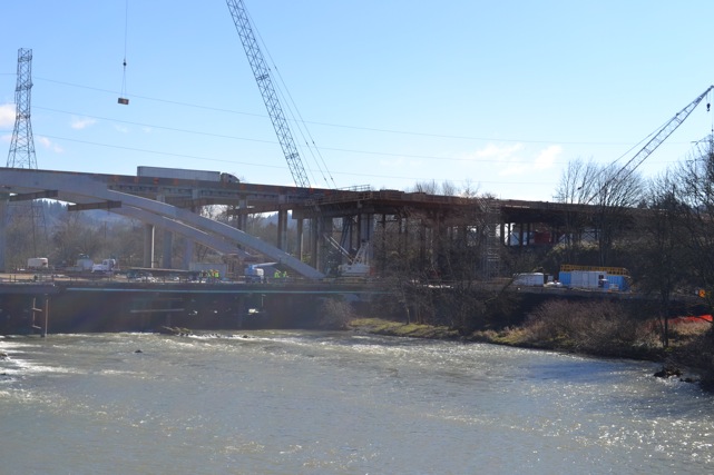
The twin arches for the new southbound I-5 Willamette River Bridge are done.  Next steps include installing the steel framework and wooden forms to pour the bridge deck.


One of the  new southbound bridge arches stratches from the middle of the river to the south bank.


Construction work continues to connect the arch on the south bank to the bridge spanning Franklin Boulevard, the railroad tracks, and the I-5 southbound off-ramp to Franklin Boulevard


A new span connects the northern arch to I-5 southbound on the north bank of the river.

Selasa, 01 Maret 2011

ODOT Listens to Citizens

From ODOT- As the ODOT Area Manager for Lane County, I see firsthand the benefits of community input on our various capital projects. The Willamette River bridge project is a great example of citizens working with ODOT to achieve results that meet the required standards, while reflecting local community values.

The Citizen Advisory Group (CAG), made up of representatives of nearby neighborhoods, local jurisdictions, local organizations, and citizens at large has worked on the project since the early planning stages in 2007.

The CAG provides a key link between the community and the project. Its members give feedback on issues ranging from bridge engineering, placement and appearance of sound walls, design enhancements and landscaping to the park paths and open spaces surrounding the project. They also assist in reaching out to stakeholder groups through open houses and public forums.

The frequent dialogue between CAG members, ODOT and other key stakeholders is thoughtful and thorough; seeking concensus before moving forward. These volunteers contribute many hours to listen, learn and provide input. Their participation is invaluable and leads to a better community outcome.

The success of the Willamette River Bridge project reflects the partnership between the CAG and ODOT. Everyone is focused on creating a lasting community asset.

Thanks to all our local citizen stakeholders for their past and ongoing participation.

Jumat, 11 Februari 2011

A lot of concrete, rebar and other materials

From ODOT- Have you ever wondered about the amount of material it takes to construct a new bridge, especially one as large as the new southbound Willamette River Bridge?


Visitors on the project tours often ask this question. Here’s the answer.


The finished portion of the bridge will be made up of 2.7 million pounds of rebar and 7,300 cubic yards of concrete. Rebar is used to add tensile strength to concrete. It is usually made of carbon steel, and has ridges for better anchoring into the concrete.


The rebar ranges from as small as 1/2 inch in diameter up to 2.25 inches. It is labor intensive to install and link all that rebar together before the concrete can be poured.


More steel and a lot of wood was needed to build the work bridge in the river and the supports and wooden falsework where the rebar is installed and concrete poured to build the new bridge. About 14 million pounds of steel was used to drive the piles supporting the work bridge and to support the wooden falsework use to form the bridge arches. The amount of wood used on the work bridge and falsework exceeds 2 million board feet and includes 2-by-4’s, 8-by-8’s and many sheets of plywood.


The crew building the bridge used these materials to create the arches you now see spanning the river and the bridge supports and beams south of Franklin Boulevard.


On a side note, the web cam is operational again, check it out.

Senin, 07 Februari 2011

Design Complete on Willamette River Bridge

From ODOT-Another important milestone has been reached on the Willamette River Bridge project. Design of the northbound bridge, along with modifications to Interstate 5 lanes and ramps is complete. This is the last major engineering design work needed to guide completion of the new I-5 bridges. Finishing the design work is a result of close collaboration between Oregon Department of Transportation, OBEC Consulting Engineers, Hamilton Construction and a large group of key community stakeholders.


While the bridge and roadway design work has been completed other design efforts are ongoing. Regional artists continue to work with stakeholders to design artistic enhancements to the project area.


The team, especially our committed stakeholders, is to be complimented on a job well done. I know the community will be pleased with the results when the entire project is complete.

Selasa, 01 Februari 2011

Beyond the arches

From ODOT- With all the attention that’s been focused on building the graceful arches for the new I-5 Willamette River Bridge, you may not realize that they are but part of a series of four independent bridges linked together form a single span from the north bank of the Willamette River to the south end of the project past Franklin Boulevard.

While the arch spans obviously catch your eye as they prominently cross the river, they are not the longest part of the new bridge.

South of the river, the new I-5 bridge crosses over Franklin Boulevard, railroad tracks, the I-5 off-ramp to Franklin Boulevard, pedestrian paths and local creeks and drainages. The bridge over the river is 806 feet long, but the portion from Franklin Boulevard south is 900 feet long.

We’re building two more independent bridges south of the river. They will consist of box girder beams constructed on site followed by forming and pouring the bridge deck on top.

Another much smaller box girder bridge will connect I-5 on the river’s north bank to the arch bridges crossing the Willamette.

Each independent bridge must be tensioned separately. Once tensioned, the deck of the new southbound bridge will become one continuous smooth surface, from the north bank of the Willamette River to south of Franklin Boulevard.


The new bridge on the north bank of the Willamette River.


Bridge construction south of the river.